

 ← Projects
 One district, two separate targets.
Stakeholder Gold Corp. holds a 100% ownership interest in the 22,700-hectare Ballarat Gold-Copper Project located in the geographical center of the White Gold District of the Yukon Territory, Canada. The Yukon Territory is a Tier-1 Mining Jurisdiction hosting globally competitive mineral endowments in a regulatory environment favorable to responsible extractive initiatives.

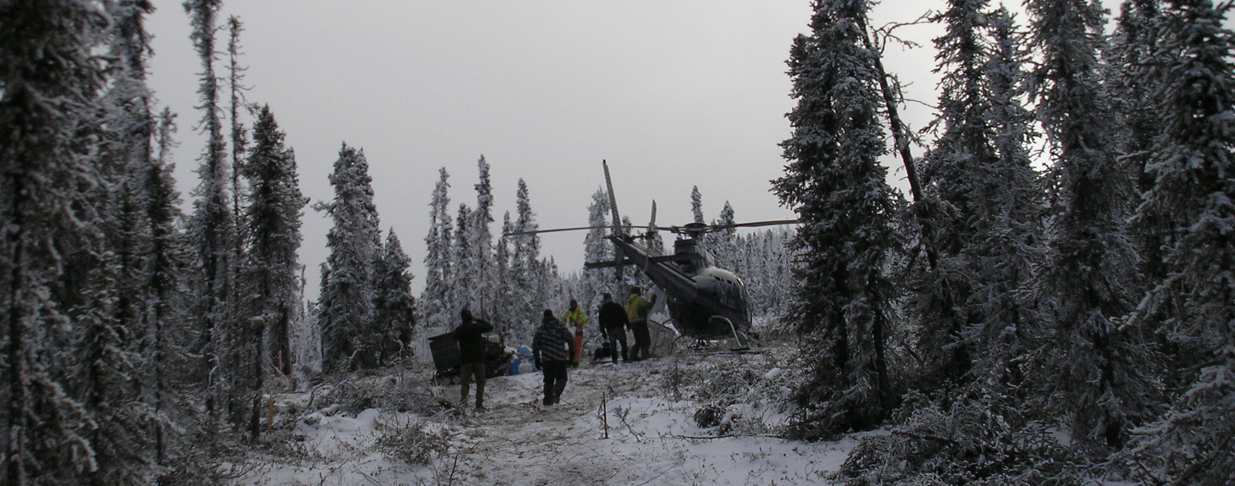
Skye · gold target, drilling underway along strike and at depth.
The Skye Gold zones (Skye North and Skye South) are located in the north-center section of the Ballarat Project claims and consists of two, subparallel, gold-in-soil trends each extending for almost 2 kilometres along strike on ENE oriented structures. The southern of these two structures (Skye South) is also open to the southwest. These subparallel structures are found to be coincident with low-resistivity zones outlined in VLF-EM surveys. These low resistivity zones dip moderately to steeply northwest and are interpreted to be primary structural controls for gold mineralization in the district.
This structural setting is very similar to other known zones of gold mineralization in the area, including the Golden Saddle Deposit, which is located some 30 km to the northwest.
The Skye Gold zones (Skye North and Skye South) are situated north and east of Ballarat Creek within the northern sector of the Company's claim holdings. They begin approximately 1-3 km west of the Northern Access Route (NAR) where the NAR traverses the northern section of Stakeholder's Ballarat claims group, and they extend to the west from there over a considerable strike extent (~ 2 km).
The Loki Critical Mineral corridor is first detected approximately 8 km south of the Skye Gold zones and is believed to extend for almost 35 km to the east along newly acquired claims (July.2026). The first targeted anomaly was a 2.3 km x 530 m anomalous copper in soils (nickel-cobalt-platinum group metals) signature associated with a WNW trending ultramafic intrusive unit. This intrusive unit is now interpreted to host potential for Alaskan style Ni-Cu-PGE mineralization (press release June 2nd, 2026).
The Loki Critical Mineral corridor is situated east of Ballarat Creek within the southeast sector of the Company's claim holdings. The Loki Critical Minerals corridor ultramafic intrusive unit is evidenced on both sides of the Northern Access Route (NAR) where the NAR traverses the southern section of Company claims.
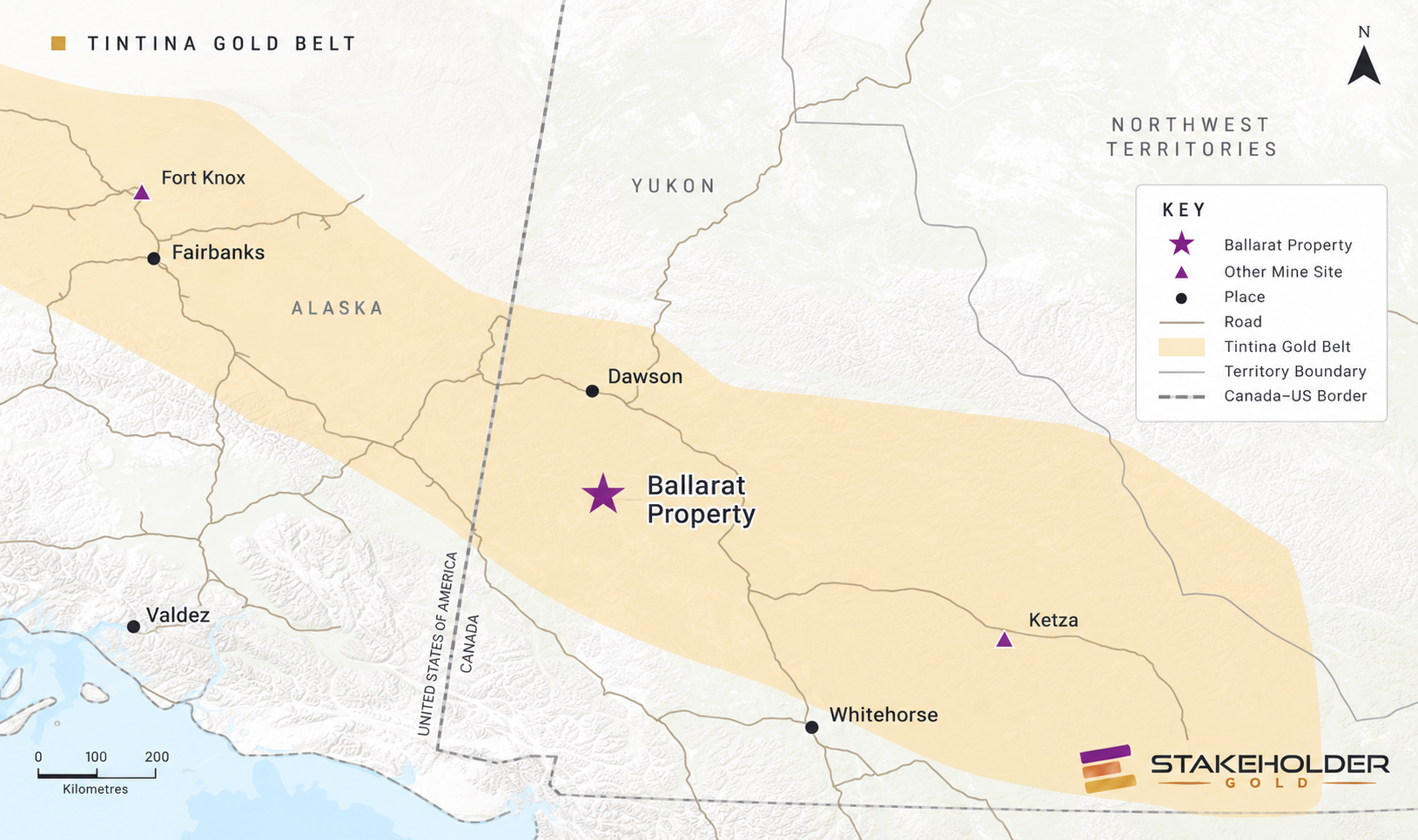
Figure #1 — Tintina Gold Belt
The Ballarat Gold-Copper Project is located within the prolific Tintina Gold Belt which extends for more than 1,000 km from the Yukon Territory into the State of Alaska along the northern length of the North American Cordillera (Figure #1).
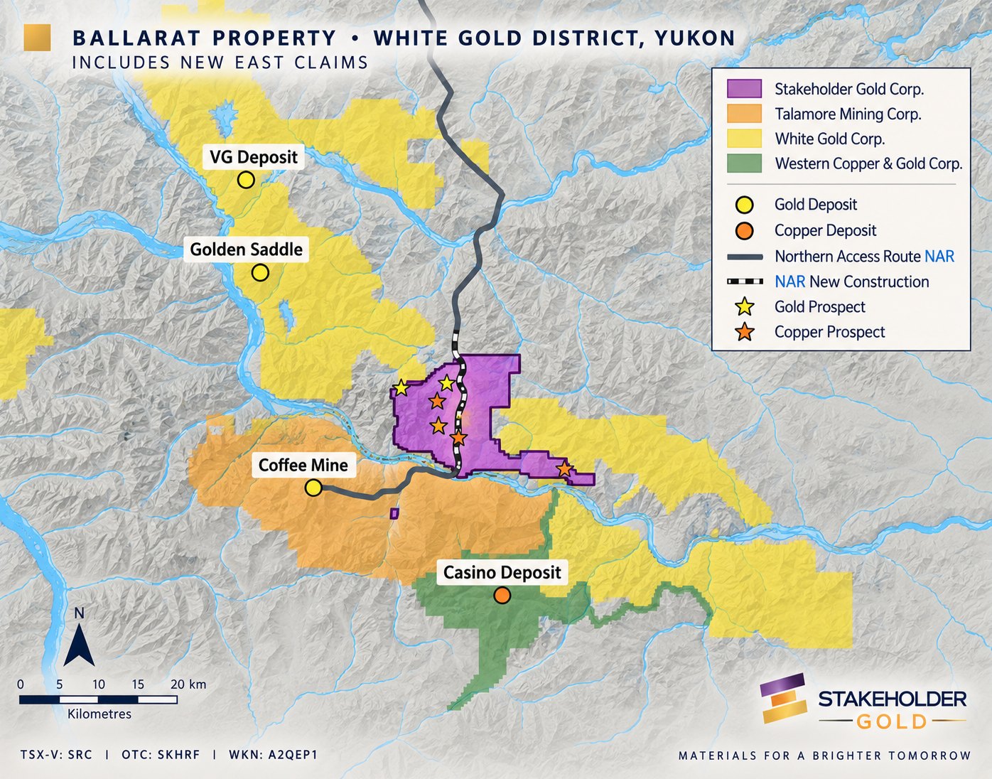
Figure #2 — Ballarat Gold-Copper Project, Regional Setting
The Ballarat Gold-Copper Project covers 22,700 hectares and is situated northeast of the Talamore Mining Corp.'s (TSX-V: TALA) Coffee Mine Project, due north of the Western Copper and Gold Corp. (TSX: WRN) world class Casino Project, and south, west and east of the White Gold Corp. (TSX-V: WGO) White Gold Project (Figure #2).
The Company's Ballarat Project claim group also includes title to 10 claims located within the nearby Fuerte Metals Corp. (TSX-V: FMT) Coffee Mine Project which is being developed by Talamore Mining Corp. (TSX-V: TALA) south of the Yukon river (Figure #2).
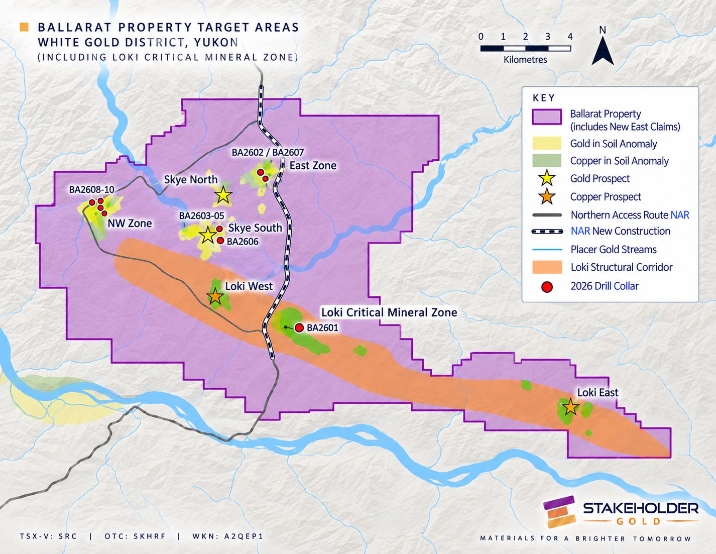
Figure #3 — Ballarat Gold-Copper Project, including Loki Critical Mineral zone
The Ballarat Gold-Copper Project is located in the geographical center of the prolific White Gold District. A little over 20 km of the Northern Access Route (NAR), which is currently under construction and which will provide road access from Dawson City to the Coffee Mine Project, is being developed through the middle of company claims. The Northern Access Route will bring significant logistical advantages to project development and will support the long term economic prospects of the entire district (Figure #3).
"Our objective for 2026 is to be able to deliver evidence for new large-scale discovery potential on separate gold and copper targets on the company's 100% owned Ballarat Gold-Copper Project located in the geographical center of the White Gold District of the Yukon Territory, Canada. We have worked progressively towards this objective over several exploration seasons. 2026 is expected to be a pivotal year for Stakeholder and for our understanding of the mineralogical potential of the gold and copper trends, respectively, that we have identified and outlined on Ballarat."
"We have the potential to identify two new discovery areas which are separated by some 8 km, and which are located on either side of the Northern Access Route (NAR) which is now under construction and which traverses just over 20 km through the center of company claims. The locational advantages of these geological targets, when combined with our understanding of structure and footprint, can lead us quickly to an estimation of size and potential."
— Christopher J. Berlet, BASc (Mining), CFA, CEO & Director
East zone
The East zone target area has been significantly enlarged. 2026 drilling confirmed bedrock gold in this structure located at the headwaters of prolific placer gold producing Barker Creek (press release September 22nd, 2026).
What originated as just 6 contiguous gold anomalous ridge & spur soil samples has been expanded to an area at least 600 m northeast-southwest by at least 350 m northwest-southeast; the gold anomaly remains open to the northeast. Two float rock samples of quartz feldspar biotite gneiss collected from the East zone, strongly altered with quartz, sericite and ankerite, yielded values of 0.759 g/t and 0.587 g/t gold. Interpretations of DEM topography and satellite imagery suggest that the East zone occurs at the confluence of three major faults.
Soil lines have been extended to the NE and SW (100 m lines x 50 m stations) and in-filling soil samples have been taken through the core of the anomaly (50 m lines x 25 m stations).
Northwest (NW) zone
Gold structures were intersected in all three drill holes of the 2026 program that targeted the NW zone (press release September 22nd, 2026). The NW gold-in-soil anomaly has two parallel zones, each extending for approximately 2 kilometres, across an area hosting high gold-in-soil values (up to 796 ppb) and 3 historic grab samples grading 31.7 g/t Au, 25.35 g/t Au and 3.4 g/t Au (collected in 1991).
The 2016 Phase I program at the NW zone included six lines of GT Probe sub-soil rock sampling (425 samples @ 5 m station spacing) and in-fill soil sampling (159 samples) where the terrain was too steep for the GT Probe to have access. Four of the six GT probe lines tested approximately 400 m of apparent strike length of the interpreted northeast-southwest trend and straddle the 2010 trenches on either side. A grab rock sample from one of the reclaimed trenches ran 1.492 g/t Au.
Fifteen lines of DC induced polarization/resistivity were also surveyed over a distance of 1,800 m. Interpretation of the geophysical data indicates that there may also be a series of east-west trending, potentially mineralized structures in addition to those previously interpreted trending northeast-southwest. The soil geochemistry has shown continuity in the gold anomalies, both along the northeast-southwest and east-west trends.